Agritech AI in Africa is asked to make serious decisions: whether a farmer qualifies for a loan, whether an insurance payout should trigger, which farms a subsidy programme should reach, what advice a farmer gets about a sick crop. Each of those decisions rests on a model that learned from data, and in African agriculture the data that matters most is also the hardest to get.
This guide covers what agritech models actually learn from, why satellite imagery is necessary but not sufficient, how field agents close the gap, and what a usable agricultural training dataset looks like.
What Agritech Models Actually Learn From
A production agritech model rarely runs on one data source. Most combine several layers, each answering a different question about a farm:
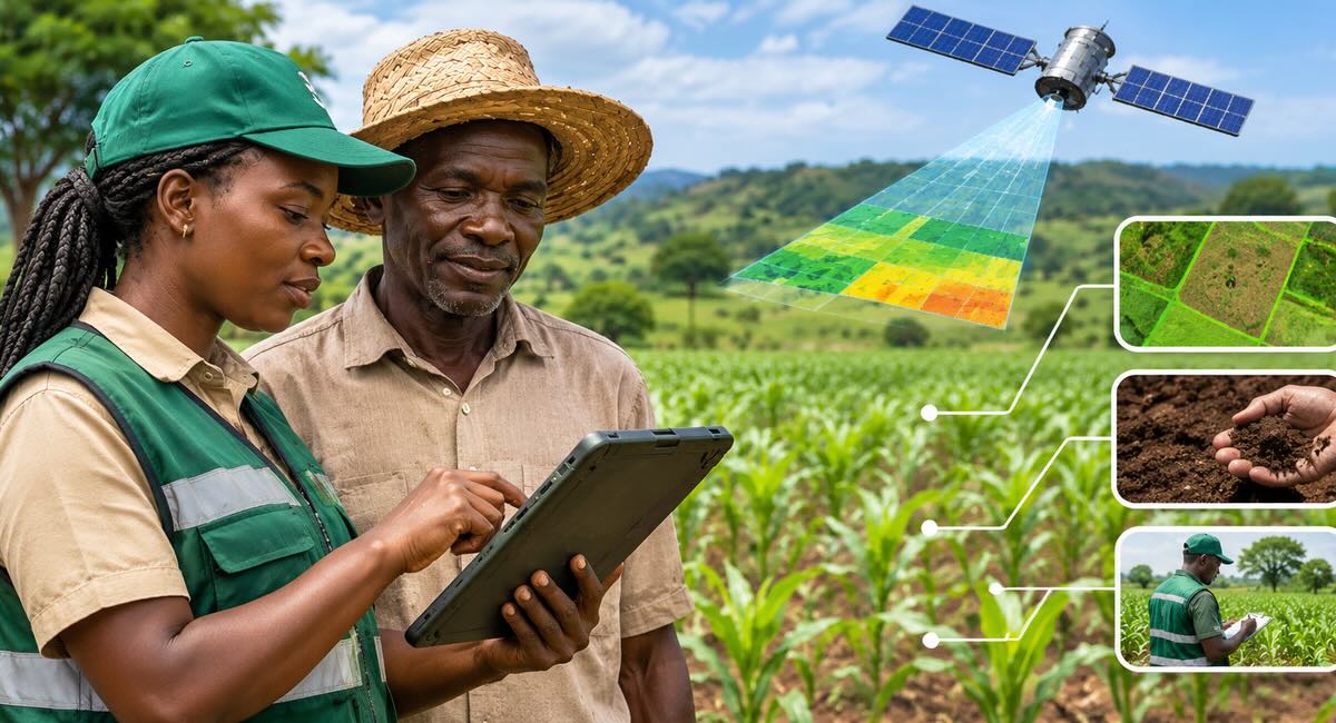
- Satellite imagery. Optical imagery such as Sentinel-2 shows vegetation health and change over time. Radar (SAR) imagery such as Sentinel-1 sees through cloud. Commercial high-resolution imagery resolves individual fields and boundaries.
- Field photos. Geotagged smartphone photos of crops, leaves, pests and harvests, taken on the ground.
- Farm boundaries. GPS-walked or digitised polygons that say exactly which pixels belong to which farm.
- Agronomic records. Crop type, variety, planting date, inputs used, growth stage and, eventually, the harvested yield.
- Climate and soil data. Rainfall, temperature, drought indices and soil properties for the farm's location.
- Farmer-reported information. What farmers say about their farms, often by voice or chat in Hausa, Yoruba, Swahili, Pidgin or another local language.
The first and last layers are where Africa differs most from the markets most agritech models were built for. Satellite imagery is plentiful and often free. Reliable labels that say what the imagery actually shows are not.
Why Satellite Imagery Alone Isn't Enough
Satellites show what is changing. They don't, on their own, tell you what is true. Four features of African farming make that gap wider than elsewhere.
1. Small, irregular plots
Most farms in sub-Saharan Africa are smallholdings, many under two hectares, with irregular boundaries that follow paths, streams and family inheritance rather than straight lines. At 10-metre resolution a small plot covers only a few dozen pixels, and the pixels on its edges mix the farm with its neighbours, paths and trees. A model trained on large, rectangular fields in the US or Europe has rarely seen anything like it.
2. Intercropping and mixed systems
Maize grown with beans or cowpea, cassava under tree crops, several crops staggered across one season: intercropping is common and sensible, and it confuses crop-type classifiers built for one crop per field. The spectral signature of a maize-cowpea plot is not the signature of maize.
3. Cloud cover in the growing season
In much of the continent the main growing season is also the rainy season, so optical imagery is often blocked by cloud at exactly the moments a model most needs to see, such as planting and early growth. Radar helps, but it is harder to interpret and needs its own labelled examples.
4. Labels that don't transfer
Most large public crop-type and yield datasets come from outside Africa. Local varieties, planting calendars, farming practices and even crop names differ. A model can score well on a benchmark and still misclassify a Kenyan or Nigerian farm, for the same reason global language models struggle with African languages: the training data didn't represent the reality the model now has to serve.
Ground Truth: The Scarce Ingredient
Ground truth is an observation recorded on the farm itself that confirms what the satellite or the model is inferring. For agritech, a useful ground-truth record usually includes:
- A verified farm boundary, walked or confirmed on site
- Crop type and variety, including any intercrops
- Planting date and current growth stage
- Geotagged, time-stamped photos of the crop
- Observed problems such as pests, disease, flood or drought damage
- Harvested yield at the end of the season
Two things make ground truth expensive. It has to be collected in person, across scattered and often remote farms. And it is time-sensitive: a planting date or a crop stage has to be recorded during the season, because nobody can go back and observe it later. Miss the window and that season's satellite imagery loses most of its training value.
This is also why synthetic data can't replace field collection here. A generator can produce plausible crop images, but it can't tell you what was growing on a specific farm in Kaduna on a specific day.
Field Agents: Collecting Ground Truth at Scale
The practical answer is a trained network of people on the ground. Agronomists, extension officers and field enumerators already know local crops, seasons and farming communities. With the right tools and training, they can turn that knowledge into structured, verifiable training data.
That is the model behind the CropSense Agricultural Intelligence Network, a certified network of field agents in Nigeria and Kenya who verify farm boundaries, crops and acreage, record planting dates and validate satellite alerts through paid field assignments. A few design choices make the difference between field data a model can learn from and field data that quietly corrupts it:
- Verified, trained agents. Every agent completes ID checks and field training before receiving assignments, so the same observation is recorded the same way across regions.
- Structured evidence capture. Agents submit boundaries, photos and notes through an app against a fixed task, not free-form reports, which keeps records consistent and machine-readable.
- Cross-checking against satellite evidence. Submissions are compared with what the imagery shows and independently reviewed. Duplicate farms, implausible boundaries and repeated records are flagged before they enter a dataset.
- Paying for quality, not volume. Agents are paid for validated assignments, which rewards accuracy rather than the number of records submitted.
- Consent first. Agents collect only what a task needs, with farmer consent recorded, and access to farmer records is restricted by role.
Satellites and field agents work best as a loop rather than as alternatives. Satellite monitoring flags where something unusual is happening, field agents confirm what it actually is, and each confirmed observation becomes a labelled example that makes the next satellite alert more reliable. Platforms such as CropSense AI are built around this loop, pairing continuous satellite monitoring with field visits only where physical evidence is needed.
Labelling Agricultural Data: What Good Looks Like
Collection is only half the work. Raw field photos and imagery still need labels, and agricultural labelling has its own pitfalls:
- Use domain experts for diagnostic labels. Telling a nutrient deficiency from an early fungal infection on a cassava leaf is an agronomy judgement, not a generic image-tagging task. Disease and pest labels should be made or reviewed by people with agronomy training.
- Map local names to a standard taxonomy. The same crop or pest can have several local names across languages and regions. Your annotation guidelines need a mapping from local terms to one label set, with photo examples of each class.
- Label intercrops explicitly. Give mixed plots their own classes, or record a primary crop plus intercrops, instead of forcing every farm into a single crop label.
- Draw boundaries to a rule. Decide whether field edges, paths and boundary trees are inside or outside the polygon, and apply the rule consistently.
- Measure agreement. Have a sample labelled by two or more annotators and track inter-annotator agreement. Low agreement on a class usually means the guideline is unclear, not that the annotators are careless.
Where the Data Gets Used
Good agricultural training data is valuable because the decisions built on it are consequential:
- Agricultural lending. Banks and microfinance lenders use farm-level evidence, such as verified acreage, crop history and productivity, to assess farmers who have no conventional credit record. CropSense's tools for lenders and insurers combine satellite monitoring with field-verified observations for exactly this.
- Parametric insurance. Index-based cover pays out when an agreed event, such as drought or flood, is detected. The trigger is only as fair as the data used to calibrate it against real losses on real farms.
- Government and donor programmes. Input subsidies, farmer registries and resilience programmes need to know which farms exist, what they grow and whether support reached them.
- Advisory. Crop-advice assistants need labelled images to diagnose problems, and they need to understand farmers' questions in local languages, which brings in the same language data challenges as any African conversational AI product.
Building an Agritech Training Dataset: A Checklist
- Start from the decision. Define what the model will decide (crop type, yield estimate, disease, credit risk) and which ground-truth fields that decision needs.
- Plan around the season. Schedule field collection for planting, mid-season and harvest. Time-sensitive observations can't be recovered later.
- Sample for representativeness. Cover the regions, farm sizes, crops, intercropping systems and farming practices the model will meet in production, not just the farms that are easiest to reach.
- Pair every field record with imagery. Link each observation to the satellite scenes for the same farm and date, so it can be used as a training label.
- Hold out an evaluation set. Keep a separate set of verified farms, ideally from different districts and seasons, to measure how well the model generalises.
- Document consent and provenance. Record farmer consent, who collected each record, when and how, so the dataset can stand up to audits by lenders, insurers and regulators.
Building AI for African agriculture?
DataLens Africa designs and runs data collection and annotation projects for agritech teams, from field photo collection and boundary labelling to agronomist-reviewed disease labels and local-language farmer conversations. Book a call to talk through your dataset.